Pinniped Tagging and Tracking in Southeast Virginia
Introduction & Objectives
The lower Chesapeake Bay and Virginia nearshore waters represent one of the busiest hubs of naval activity on the east coast and hosts numerous pierside facilities, bases, vessels, shipyards, and in-water training ranges. Seals seasonally inhabiting and transiting through these areas could be impacted by military activities including vessel traffic of all sizes, dredging, pile driving and other activities. Understanding seals’ habitat use in the vicinity of naval activities is critical to mitigating potentially harmful interactions and obtaining appropriate environmental permits. The information gathered from this project will provide valuable baseline data needed for the future assessment of seal movement and site fidelity along the Mid-Atlantic coast and especially for in-water training associated with Joint Expeditionary Base (JEB) Little Creek-Fort Story, and Naval Station Norfolk and Naval Air Station Oceana - Dam Neck Annex.
Navy biologists have been researching seal occurrence in the region since 2013 and conducting systematic haul-out counts in the region since 2014. The information and data collected to date indicate that seals are probably utilizing the area to a much greater extent than previously thought, and that there is a regular seasonal occurrence of seals in the region between fall and spring. Based on previous Navy research efforts, citizen science, and stranding records, the species that could be included in this effort are predominantly harbor seals, as well as grey seals, and on rare occasions, harp seals. While there is an improved understanding of the seasonality of seals to the region at certain haul-outs, there is a void of information on the movements of individuals within the region, their migratory pathways, or habitat use on a broader spatial scale, which merits further monitoring.
This project is being undertaken to understand seal movement in the area, to determine when seals migrate in and out of the region, and where they migrate to in the spring and summer. Increased knowledge of the movements, habitat utilization, and seasonality of seals found in the lower Chesapeake Bay and Virginia coastal waters will allow the Navy to limit interactions with these protected species, design better mitigation measures where interactions are unavoidable and obtain the appropriate authorizations to maintain environmental compliance.
Technical Approach
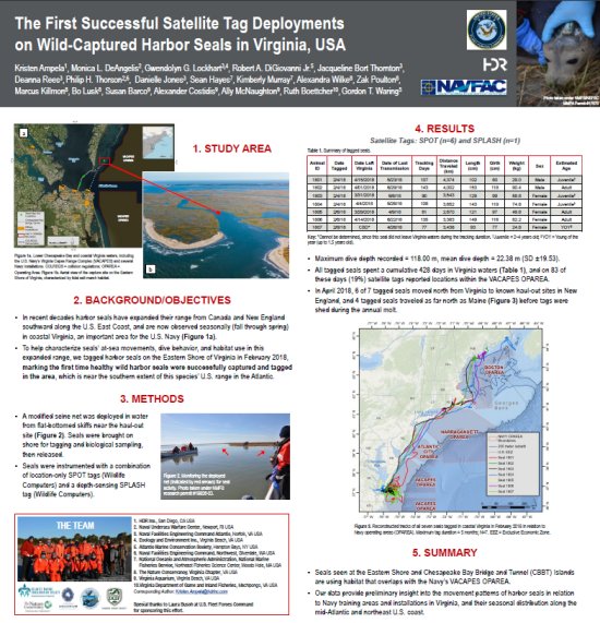
The project focuses on capturing, tagging, and releasing healthy harbor seals (adults if possible) at one of their known haul-out sites in southeast Virginia. The tags utilized are Wildlife Computers satellite-linked tracking tags (combination of SPOT6, SPLASH10, and SPLASH10-BF). The SPOT6 tag is a position-only tag that tracks the seals’ general movements, and when they come out of the water onto land (“haul out”). The SPLASH tags utilize depth sensors to record dive data which is used to infer foraging behavior. The SPLASH10-BF tags add Fastloc GPS technology (Wildtrack Telemetry Systems) to acquire fine-scale movement data. VEMCO acoustic transmitter tags were also used during the first field season will no longer be deployed on seals for future tagging efforts.
Researchers attach satellite-tracked tags to seals using methods consistent with similar projects conducted on these species, and in accordance with all stipulations of NMFS permit #21719. A suite of biological samples are collected in accordance with permit stipulations, which may include scat, blood, blubber (via biopsy), vibrissae, and fur.
Tag return data is used to conduct home range analyses, and to create maps of the seals’ transits and haul-out locations. Dive data will feed into the Navy Acoustic Effects Model (NAEMO) in order to inform the Navy’s environmental permitting process. The Principal Investigator from Atlantic Marine Conservation Society, and capture team leads from Naval Undersea Warfare Center Division Newport, each have 20+ years of experience with seal research and extensive experience in capturing and handling seals. The capture/tagging team also includes experienced marine mammal researchers representing the Navy’s U.S. Fleet Forces Command, Naval Facilities Engineering Command Atlantic, Naval Undersea Warfare Center Division Newport, the Atlantic Marine Conservation Society, Virginia Aquarium, HDR, Inc., The Nature Conservancy, Virginia Department of Game and Inland Fisheries, and National Marine Fisheries Service.
Progress & Results
In total, 14 satellite tags were deployed on harbor seals between 2018 and 2023, with one season without tagging effort due to the COVID-19 pandemic. VEMCO acoustic transmitter tags were deployed the first year of the study on seven of the seals. Data from the satellite-linked tags is available on Movebank.org. While the fieldwork portion of this project is likely complete in Virginia, planning and coordination for future analyses and collaborations is in progress.
 The First Successful Satellite Tag Deployment on Wild-Captured Harbor Seals in Virginia, USA
World Marine Mammal Conference, Barcelona, Spain - December 2019
Project Information
Location: Lower Chesapeake Bay and Virginia Eastern Shore
Timeline: 2017-23
Funding: FY16 - $40K, FY17 - $170K, FY18 - $46K, FY19 - $468K, FY20 - $161K, FY21 - $79K, FY22 - $290K, FY23 - $80K
Points of Contact
Principal Investigator
Robert DiGiovanni
Atlantic Marine Conservation Society
Capture Team Leads
Monica DeAngelis
Naval Undersea Warfare Center
Phil Thorson
NAVFAC Northwest
Project Managers
Deanna Rees
NAVFAC Atlantic
Environmental Conservation, Marine Resources Section
Kristen Ampela
HDR, Inc.
Reports & Data
2017-18 progress report
2019-20 progress report
2018-22 final report
Tagging data
Animal Telemetry Network
Associated Projects
Haul-Out Counts and Photo-Identification of Pinnipeds in Lower Chesapeake Bay
Time-lapse Camera Surveys of Pinnipeds in Southeastern Virginia

